The Salt Range is a hill system in the Punjab province of Pakistan, deriving its name from its extensive deposits of rock salt. The range elongates from the Jhelum River to the Indus, across the northern portion of the Punjab province. The Salt Range contains the great mines of Mayo, Khewra, Warcha and Kalabagh, which yield prodigious supplies of salt. Coal of a medium quality is additionally found.
- Sakaser and Tilla Jogian are the highest peaks of Salt Range.
- Khabikki Lake and Uchhali Lake are lakes in the Salt Range
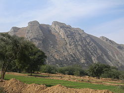
Salt Range in Mianwali District, Punjab, Pakistan
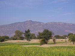
Tilla Jogian, the second highest peak in the Salt Range
History
The Gakhars and Janjua Rajputs had engaged in an endless battle for sovereignty over the Salt Range.
The history of this region (the Salt Range) from the thirteenth century onward had been a sickening record of wars between the Janjuhas and the Gakkhars for political ascendancy.
But later in 16th century Awan (tribe) of ancient repute drove out Janjuas and Ghakhars from the western parts of Salt Range. According to the Emperor Babar the Jud and the Janjuha were “two races descended from the same father, “[2] who from old times had been rulers of the hills between Nilab and Bhera, that is, of the salt range. “On one-half of the hill lived the Jud, and on the other half the Janjua.” The Awans now occupy western half of these hills towards Nilab.[3]
Kathwai
Two interesting sites are close to Kathwai, Kutte Mar and Tulaja fort. At Kuttee Mar to the Northeast of Kathwai are Muslim graves made of Kangar and the purported grave of a dog that is said to have died defending the wedding procession of its owner from an attack by bandits. Kutte Mar may have been the place where the Khura inscription of Toramana was found (Buhler 1891-92, 238-41; Sircar 1965: 422-4). If this assessment is correct, a Buddhist monastery was established here around 500. A.D. This inscription and another fragmentary inscription found at Sakaser (Pakistan Archaeology 5, 1968: 284-70) confirm that this area was a flourishing, centre for Buddhism, which is borne out by the extensive archaeological remains.
The Tulaja fort is located on a huge rock outcropping with sheer cliffs overlooking the shrine of Kacchianwalla and the Punjab plains. The entire area is covered with the ruins of defensive walls, houses, and other structures made of large stone blocks. Although one building has been identified as a mosque, it is very difficult to distinguish other religious, military or civil structures. One of the most interesting features is a large square tank made of the flat rectangular bricks, which may have supplied water so that the fort could withstand a siege. Comparing this tank with those in other forts may help in assigning a relative date to its construction. In addition to architectural styles, evidence from any coins, which are found here, may help to indicate if this city belonged to the period of the Turk Sultans, Lodhis or Mughals. Extensive remains of a cemetery and other settlements are on the slopes below the fort. There are also supposed to be some remains on Tulaji across the valley from Talaja.
People

Motorway passing through the Salt Range
